A point cloud is a massive collection of data points that represent the external surface of an object or space within a three-dimensional coordinate system (X, Y, and Z). These dense datasets are created using 3D laser scanning (LiDAR) or photogrammetry technology, where scanners emit beams or capture images to record millions of precise measurements, effectively creating a digital representation of the physical world.
Point cloud modeling is the process of turning massive datasets of 3D points into usable 3D models, 2D plans, or Building Information Models (BIM). While raw scans offer high visual accuracy, they are composed of unconnected points that lack semantic meaning; the software sees coordinates rather than “walls” or “pipes.” Therefore, modeling is necessary to convert these “dumb” points into functional building elements, enabling architects and engineers to perform structural analysis, detect clashes, and plan renovations with millimeter-level precision.
This comprehensive guide explains everything you need to know about point cloud modeling. It will guide you through the technical workflow from data acquisition to processing, examine the specialized software used in the industry, and highlight key applications in the built environment. Finally, it explores how ViBIM utilizes this technology to deliver professional Scan-to-BIM services for complex construction projects.

What is Point Cloud Modeling?
Point cloud modeling is the process of taking a 3D point cloud and transforming it into a 3D model, 2D plans, or BIM deliverables. While the raw scan data captures the physical reality, it remains unstructured data until processed.
This workflow involves cleaning, aligning, and interpreting these “dumb” geometric points to create accurate “as-built” representations, enabling detailed analysis, visualization, and digital twins of real-world objects or environments, bridging the gap between physical reality and digital design.
To successfully execute this transformation, however, it is essential to first understand the fundamental nature of the raw point cloud data being manipulated.
Understanding Point Cloud Data
A point cloud is a collection of data points defined by a coordinate system (X, Y, and Z axes) that represent the external surface of objects or environments. Beyond basic coordinates, each point can carry supplementary data that adds layers of context, such as:
- RGB (Red, Green, Blue): Color values that give the model a photorealistic appearance.
- Intensity: A measure of the return strength of the laser pulse, which helps differentiate between materials.
- Normals: Vectors indicating the orientation of the surface at that point.
- Timestamps: Data on when the point was captured, useful for monitoring changes over time.
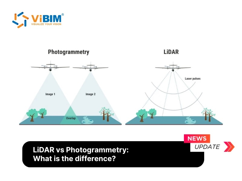
These massive datasets are generated primarily through 3D laser scanning (LiDAR) or photogrammetry. As the scanner sweeps an area, it emits laser beams that bounce off surfaces and return to the sensor, recording the precise distance and location of millions of points to create a dense digital record of the physical world.
However, despite its visual fidelity, this data remains unstructured; the computer perceives individual points rather than identifying distinct elements like “walls,” “pipes,” or “doors.”

The Difference Between a Point Cloud and a 3D Model
Confusion often exists between the raw scan and the final model. It is crucial to differentiate the two:
- Point Cloud: This is the raw survey data. It is composed of millions of unconnected points. It is heavy in file size and non-intelligent. You cannot query a point cloud to ask, “What is the thermal resistance of this wall?” because the software only sees coordinates, not building elements.
- 3D Model: This is the output of the modeling process. It consists of intelligent objects (walls, beams, windows) with defined parameters. A 3D model is lighter, structured, and contains semantic data necessary for analysis, scheduling, and quantity takeoffs.
Therefore, Point Cloud Modeling is necessary because it converts static, heavy, and unintelligent survey data into a lightweight, semantically rich, and actionable format that professionals can use for design modifications, engineering analysis, and facility management.
Why is it necessary to convert Point cloud data?
It’s necessary to convert point cloud data because raw scans are massive, unstructured datasets that are hard for most software and users to work with, and clients need clean, editable, and standardized formats like BIM models or CAD drawings (DWGs) to effectively perform design, analysis, and fabrication.
Key reasons for Point Cloud modeling:
- Efficient Data Management: Raw point cloud files are notoriously massive (often tens of gigabytes), causing software lag and making file sharing nearly impossible, whereas a constructed 3D model is significantly lighter and easier to manage.
- Intelligent Data Integration: A raw scan is merely a collection of “soulless” coordinates, whereas a 3D model (especially a BIM model) is intelligent and contains critical metadata such as material specifications, precise dimensions, and manufacturer details.
- Software Usability & Compatibility: Most standard design software cannot process unstructured datasets with millions of points; conversion creates editable files (such as meshes or CAD/BIM) that are fully compatible with industry tools like Revit or AutoCAD.
- Design & Fabrication Readiness: You cannot feed a point cloud directly into a CNC machine for manufacturing or export clean construction drawings from it; these tasks require clean, solid geometric models (CAD/Mesh) to function correctly.
- Enhanced Clarity & Interpretation: Modeling converts noisy data into clean linework, surfaces, and solids, making the layout clear and understandable for all stakeholders, from technical experts to clients.
How Point Cloud Modeling Works
The process of creating a point cloud and modeling from it involves a specific three-step workflow: Data Acquisition, Data Processing, and Data Transformation.
- Data Acquisition: Surveyors capture the target environment using 3D laser scanners (LiDAR) or photogrammetry. These devices emit beams or take high-resolution images to record millions of measurement points, ensuring complete coverage of the structure.
- Data Processing (Registration): Once captured, the data must be processed to generate a usable point cloud. This involves point cloud registration to align and stitch multiple scans or images, removing noise or outliers, and optimizing the data for further analysis. If necessary, editing processes are applied to remove unwanted elements or irrelevant data points.
- Data Transformation (Modeling): Once you have a clean and accurate point cloud, the final step is to transform the 3D point cloud to BIM models or 2D plans by using point cloud modeling software.
To successfully execute this final transformation phase and accurately extract usable building geometry from raw scan data, discover the specific software techniques required for 3D modeling from point cloud.

What Software Is Used for 3D Point Cloud Modeling?
Point cloud processing generally uses two main categories of software: Registration Software and BIM/CAD Authoring Software. The industry relies on a mix of these tools to deliver final results:
Registration Software:
- Autodesk ReCap: Essential for the pre-processing stage. It cleans and indexes raw scan files, converting them into formats (RCP/RCS) compatible with authoring tools.
- Leica Cyclone: A powerful registration tool used to align and clean massive datasets before export.
BIM/CAD Authoring Software:
- Autodesk Revit: The industry standard for BIM. It allows users to import the processed point cloud and use it as a guide to model architectural, structural, and MEP elements.
- ArchiCAD: A robust alternative to Revit, favored by architects for its intuitive handling of point cloud data for design modeling.
- Tekla Structures: Primarily used for structural detailing, effectively handling complex steel and concrete modeling based on scan data.
Plugins & Extensions:
- Undet: Point cloud software often comes in the form of plugins designed to help you import and work with data within popular CAD programs. Tools like Undet help convert point cloud data into meshes or models directly within SketchUp or Revit.
Learn more: Our top platforms that streamline the entire workflow in our comprehensive guide to the best scan to BIM software.
Key Applications of the Point Cloud 3D Model in the Built World
Point clouds 3D Model serve as the digital foundation for capturing physical reality in precise 3D coordinates, enabling analysis, measurement, and modeling across numerous industries. This raw dataset is a foundational asset for any industry needing to visualize, analyze, or digitally convert physical spaces into actionable formats.
Key applications include:
- Scan to BIM workflows: The most transformative application in modern construction is Scan to BIM. This is the specialized process of converting the raw geometric point cloud data into an intelligent, data-rich Building Information Model (BIM). This intelligent model unlocks advanced capabilities like clash detection, automated quantity takeoffs, and accurate renovation planning.
- As-Built Documentation (AEC): This is a primary use in construction. Point clouds capture the exact “as-is” conditions of a building, allowing teams to verify work, check for deviations, and create accurate documentation for retrofits without physical reconstruction.
- Civil Engineering & Volumetrics: Scans are used to generate highly detailed topographic maps (DEMs/DTMs) for land surveying. In mining and civil engineering, this data is used for precise volumetric analysis to calculate stockpile inventories or earthworks (cut-and-fill) volumes.
- Manufacturing & Reverse Engineering: In industrial settings, point clouds enable high-precision quality control by comparing manufactured parts against design models. It also enables reverse engineering, where a physical object is scanned to create a new, editable digital model.
- Autonomous Navigation & Robotics: LiDAR-based point clouds serve as the “eyes” of autonomous vehicles and drones, enabling them to perceive their environment in 3D for real-time navigation and obstacle avoidance.
- Environmental & Heritage Preservation: This technology enables the non-invasive digital preservation of historical sites. In forestry and environmental science, scans are used to measure vegetation, assess canopy density, and calculate biomass.
- Entertainment & Virtual Reality (VR): Game developers and filmmakers use scans of real-world locations to create photorealistic 3D assets and immersive virtual-reality experiences without having to model from scratch.
- Forensics & Public Safety: Investigators scan crime scenes or accident sites to preserve evidence in 3D. This allows for precise measurements and trajectory analysis long after the scene has been cleared.
Key Benefits of Modeling from Point Cloud Data for AEC
Transitioning from manual surveying to point cloud modeling offers distinct advantages for AEC professionals:
- Enhanced Accuracy and Precision: Laser scanners capture environments within millimeter accuracy. Modeling from this data ensures the digital twin accurately reflects reality, significantly reducing design errors caused by inaccurate measurements.
- Proactive Clash Detection: By overlaying the new design model against the existing point cloud, teams can identify clashes (e.g., a new duct hitting an existing beam) before construction begins.
- Cost and Time Efficiency: While the initial scanning investment may seem higher, it eliminates the need for repeated site visits. Capturing all data in a single visit prevents the “we missed a dimension” scenario, saving substantial travel and labor costs over the project lifecycle.
- Safety in Hazardous Environments: For industrial retrofits or unstable heritage sites, scanners can capture data remotely, keeping personnel out of harm’s way.
ViBIM’s Case Studies Using Point Cloud Models for BIM Modeling
At ViBIM, we specialize in using point clouds to convert into accurate BIM models ready for design, construction, and asset management. Here are examples of how we use client-provided point clouds to execute point cloud modeling in Revit:
Project 1: Large-Scale Commercial Complex (UK)
The Input: The client provided a massive 130,000m² point cloud dataset of a large commercial complex. The raw data volume was extremely high, making processing slow and collaboration difficult, especially when the client requested a major design change late in the project.
The Transformation: Our task was to create a precise LOD 300 architectural and structural Revit model for planning and renovation. When the client changed all pathway modeling from Topography to Floor elements, our team developed a Dynamo script to automate the conversion, saving 90% of the manual modeling time that would have been required.
The Result: We delivered a lightweight, accurate as-built model that successfully handled massive data and complex, late-stage client changes without derailing the project timeline.


Project 2: High-Detail Industrial Factory (USA)
The Input: We received a point cloud of an industrial factory. The data was dense and visually “messy,” with poor quality in critical areas around complex machinery, making it difficult to identify details for a specific aluminum extrusion press.
The Transformation: The goal was a fabrication-ready LOD 400 as-built model of all Architecture, Structure, and complex MEP systems. Our team cross-referenced the poor-quality scan with site images and meticulously modeled the intricate piping and electrical systems, breaking the machine into manageable sub-assemblies in Revit to ensure precision.
The Result: We delivered a clash-free, fabrication-ready model that met the client’s ±0.25-inch accuracy requirement, enabling them to proceed with a complex engineering and equipment upgrade.


Project 3: Data-Rich Educational Facility (UK)
The Input: The project involved a 4,900m² school campus captured in a detailed point cloud. The raw data provided the geometry, but the client’s primary need was informational, not just visual.
The Transformation: The key objective was an LOD 400 model where data accuracy was the top priority. The client required every element to have the correct material asset and be classified under the proper Revit Category to create a “digital asset” for long-term Facility Management (FM).
The Result: By using a multi-faceted verification process (point cloud, photos, TrueView) and adhering strictly to native Revit categories, we delivered an intelligent model that functions as a reliable database. The client can now accurately extract material quantities and schedules for future maintenance.


These projects highlight the tangible value of transforming raw point cloud data into accurate, data-rich BIM models. This specialized expertise solving challenges from massive data volumes to complex MEP systems is the core of our service.
VIBIM – Professional Point Cloud to BIM Modeling Services
Transforming the complex point cloud data described in this guide into an intelligent, actionable BIM model requires specialized expertise and advanced technology. At VIBIM, we offer professional Point Cloud to BIM Modeling Services that convert this intricate process into a streamlined, reliable solution for your project. Our team leverages over a decade of experience in the AEC industry to deliver high-accuracy Scan to BIM models that drive efficiency and minimize risk.
We are committed to precision, quality, and exceptional service. Our clients trust us for our:
- Guaranteed On-Time Delivery: With a 99% on-time completion rate, we ensure your project stays on schedule.
- Fast Turnaround Times: Our optimized workflows deliver models up to 30% faster than industry standards.
- High Accuracy & Reliability: Every model undergoes a rigorous QA/QC process to meet the highest standards of data integrity.
Partner with VIBIM to unlock the full potential of your reality capture data. Contact our Revit BIM Modeling services today to discuss your project and receive a complimentary trial.
Contact information:
- Address: 10th floor, CIT Building, No 6, Alley 15, Duy Tan Street, Cau Giay Ward, Hanoi, Vietnam
- Phone: +84 944 798 298
- Email: info@vibim.com.vn
- Website: https://vibimglobal.com/

FAQs
What is the best file format for point cloud modeling?
The “best” Point cloud file format often depends on your authoring software. However, RCP (ReCap Project) and RCS (ReCap Scan) are the preferred formats for Autodesk Revit workflows due to their optimized performance. For interoperability between different software ecosystems, E57 is the industry-standard exchange format that retains high-quality data and imagery.
How long does it take to model a building from point clouds?
The timeline varies significantly based on three factors: the size of the building, the density (quality) of the scan data, and the required Level of Development (LOD). A small residential interior might take 2-3 days, while a complex industrial facility with intricate MEP systems could take several months. ViBIM assesses these factors during the estimation phase to provide precise turnaround times.
Read Next: Deciding between a parametric BIM model and a Mesh surface? Compare the workflows to find the right fit for your project: Point Cloud Model vs. Mesh Model