Topography BIM modeling

Topography BIM Modeling from Point Cloud Services

ViBIM delivers high-precision BIM models of topographic elements such as pavements, driveways, inner yards, and surrounding open spaces based on point cloud data. Our modeling ensures seamless integration with building models, supporting accurate design coordination and planning.

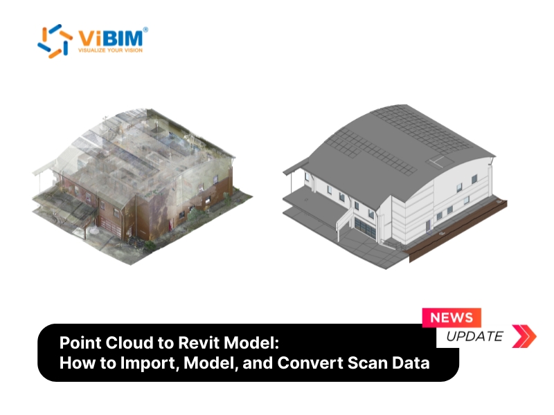
ViBIM provides Topography BIM Modeling service that transforms point cloud data into detailed, accurate Revit models of exterior environments surrounding buildings. We specialize in modeling localized exterior elements such as sidewalks, curbs, driveways, internal roads, parking lots, courtyards, and landscaped areas directly adjacent to buildings.

This service is particularly valuable for clients who require a comprehensive BIM model that extends beyond the building envelope, enabling better coordination in design, construction planning, site logistics, and facility management. By modeling these surrounding elements with high accuracy and alignment to the architectural context, ViBIM helps clients visualize site constraints, optimize layout planning, and ensure consistency between building and site models.

Our work process begins with analyzing point cloud data to classify surfaces and identify key topographic features. We then proceed to model hard surfaces using Floor tools with precise boundary definitions, create soft surfaces using Toposurface or Toposolid elements, adjust interfaces between different surface types, fine-tune elevations for accurate representation, and model auxiliary site elements as required.

With over a decade of experience in Scan to BIM Modeling Services, ViBIM applies a detail-oriented, quality-first approach to deliver topo models that are both technically precise and ready for further design development or coordination with other disciplines.

Get a quote

Our Topography BIM Modeling from Point Cloud Services Offers

ViBIM’s topography modeling services transform raw point cloud data into precise, intelligent 3D models that accurately represent the exterior environment surrounding buildings and structures.

Building at night with prism kaleidoscope/prism lens effect

Download Topography Modeling Review Checklist

To further support your topography BIM projects, ViBIM offers a comprehensive Topography BIM Modeling Review Checklist. This valuable resource can help ensure that all critical aspects of your topography BIM model are thoroughly checked and validated.

Download checklist

Benefits of Topography BIM Modeling from Point Cloud Services

In building projects where the surrounding exterior environment plays a functional or design-critical role, Topography BIM Modeling provides substantial benefits that directly impact project outcomes. This enables:

  • Creating an exceptionally accurate 3D model includes all surfaces, slopes, elevations, and distinct features like sidewalks, internal roads, and driveways, moving beyond the limitations and potential inaccuracies of traditional 2D surveys.
  • Integrate an accurate topography model with your building BIM to identify and resolve potential conflicts early. This service allows for the detection of level mismatches between the building and adjacent ground, clashes with existing site utilities, and coordination issues with landscape elements before they escalate into costly on-site rework.
  • Enhanced precise planning for landscape design, pavement layouts, circulation zones, and accurate earthwork calculations, ensuring optimal use of the site.
  • Increased precision by converting complex, real-world terrain into quantifiable and interoperable data, design assumptions are minimized. This improves model fidelity and supports parametric design iterations with fewer coordination errors.
  • Model site elements like ramps, walkways, and parking areas with precision. This supports compliance with local regulations and accessibility standards (e.g., ADA requirements) from the initial design stages.
  • The accurate topographic model aids in construction sequencing, site logistics, and provides a reliable as-built record for future maintenance, renovations, or expansions of the site.
Topography BIM modeling

Our QA/QC Process

ViBIM follows a rigorous quality assurance protocol to ensure every topographic model meets the highest standards of accuracy and reliability. Our systematic approach guarantees consistent deliverables that align with client expectations and project requirements.

  • Topographic elements are modeled using appropriate Revit system families (Toposurface, Toposolid, Floor) based on material type and functional behavior to ensure accurate classification.
  • Surface elements are modeled to match real-world slope, curvature, and elevation captured in point cloud data using sub-element editing tools and split lines for precise terrain representation.
  • Modeled elements follow naming conventions outlined in project-specific BEPs or Scan to BIM guidelines, supporting consistency across disciplines.
  • Modeled boundaries between hard and soft surfaces are cleaned using standard Revit tools to eliminate overlaps and reflect true site conditions.
  • ViBIM aligns modeling scope and detail level with client expectations, typically ranging from LOD 200–300 depending on project use.
  • Quality control includes cross-checking model geometry against point cloud references, verifying key elevation points, and conducting visual overlays with deviation analysis.

Our Topography BIM Modeling from Point Cloud Services Process

ViBIM follows a structured and meticulous process to ensure the highest quality and accuracy in our Topography BIM Modeling services. Each stage is carefully executed by our experienced team.

Featured Projects

Why Choose ViBIM?

Choosing ViBIM for your Topography BIM Modeling needs means partnering with a dedicated Revit Modeling Outsourcing team committed to precision, efficiency, and client satisfaction. We combine technical expertise with a deep understanding of project requirements to deliver models that add tangible value.

  • Specialized Expertise in Site Modeling: ViBIM has specific experience in modeling the complex details of building-adjacent topography, ensuring elements like sidewalks, driveways, and courtyards are accurately represented and integrated.
  • Custom Automation for Efficiency: Our investment in custom Revit add-ins for tasks like soft surface creation means faster modeling times without sacrificing precision, offering you quicker deliverables.
  • Client-Centric Approach: ViBIM works closely with clients to understand their specific needs and Level of Detail (LOD) requirements, tailoring our services to meet precise project goals and deliver maximum usability.
  • On-Time Delivery Guarantee ViBIM maintains a 99% on-time delivery record for projects. Our dedicated project managers track progress daily, ensuring each milestone is met according to established timelines.
  • Responsive Communication Protocol We understand that your time is valuable. That’s why at ViBIM, your emails are responded to promptly. Our project managers provide regular status updates and are always available to address questions or concerns throughout the modeling process, ensuring clear communication and transparency at every project stage.
vibim-best-topography-bim-service

Our Software Proficiency

Customer Testimonials

FREQUENTLY ASKED QUESTION

In ViBIM’s 3D modeling services, topography refers to the accurately modeled exterior areas surrounding a building, such as sidewalks, internal roads, driveways, courtyards, and landscaped zones, based on point cloud data. These elements are not large-scale infrastructure, but localized site components directly connected to the building, modeled in Revit using appropriate system families to support design coordination, elevation planning, and construction integration..

5cf08adcf9cfeeb6c397117e4636a8a1c9a22f07

Request a quote

To learn more about our Topography BIM Modeling from Point Cloud Services, please fill out the form below, and someone from our team will be in touch with you shortly.

Please enable JavaScript in your browser to complete this form.
Demo
Privacy policy
Recevie news

Latest News

What is BIM in Civil Engineering? How can BIM value Civil Engineering?

Civil engineering is the discipline that focuses on the design, construction, and maintenance of infrastructure,...

View more

3D Point Cloud Model vs. 3D Mesh Model

The fundamental difference between 3D Point Cloud Model and 3D Mesh Model is that a...

View more

BIM Level of Development Guide: LOD 100, 200, 300, 350, 400, 500

BIM Level of Development (LOD) is a set of industry specifications that defines the reliability,...

View more

A Comprehensive Guide to Converting Point Cloud Data to a Revit Model

A point cloud in Revit is a collection of 3D data points from a laser...

View more

Scan to BIM Explained: A Complete Guide to the Process, Benefits & Applications

The Scan to BIM process is transforming how complex renovation, retrofit, and heritage preservation projects...

View more

Point Cloud Modeling: Everything You Need to Know

A point cloud is a massive collection of data points that represent the external surface...

View more