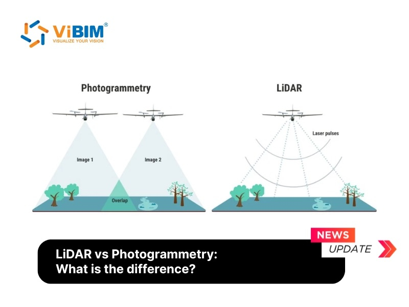
The accuracy of a 3D Laser Scan to BIM model is fundamentally dependent on the capabilities of the 3D laser scanning devices used for data capture. The precision of the point cloud data, which forms the foundation of any BIM model, is directly tied to the quality of the scanner. This article explores the primary types of professional laser scanners, their key technical features, and the criteria for selecting the right equipment for AEC projects. We will delve into Terrestrial LiDAR Scanners, Handheld 3D Scanners, and Mobile LiDAR Scanners, followed by a comparative analysis and a breakdown of the key features that determine a scanner’s performance.
Understanding these devices is crucial, as the accompanying software plays an equally vital role in processing the raw data into a usable point cloud for Scan to BIM workflows.

Types of 3D LiDAR Scanners Used in Scan to BIM
The world of 3D laser scanning is diverse, with various technologies tailored for different needs. From large-scale terrestrial scanners ideal for capturing entire buildings to nimble handheld devices for detailed work, the choice of scanner impacts the efficiency and accuracy of the Scan to BIM process. Major brands like Leica, Faro, Trimble, and Navvis offer a range of solutions, each with its own strengths. Furthermore, the software integrated with these scanners is critical for registering, cleaning, and preparing the point cloud data for BIM authoring.
Terrestrial LiDAR Scanners
Terrestrial LiDAR scanners are tripod-mounted devices that rotate from fixed viewpoints to digitize large, complex environments with high detail. They are a cornerstone of surveying and 3D capture technology in the AEC industry. By emitting laser beams and measuring their return time, these scanners create a dense and precise point cloud of their surroundings. This point cloud serves as the foundational data for creating accurate as-built BIM models, CAD drawings, and other documentation requiring precise dimensions.
Leica ScanStation P50
The Leica ScanStation P50 is a premium, long-range 3D laser scanner built for demanding surveying and engineering projects that require extreme accuracy over vast distances. It is designed for demanding environments and large-scale projects. With a 360° horizontal and 290° vertical field of view, large 256 GB SSD storage, and extended battery options, it supports uninterrupted fieldwork.
Ideal for capturing tall buildings, large infrastructure, open-pit mines, and inaccessible locations, the Leica P50 is a robust all-in-one solution for professionals who demand speed, accuracy, and reliability in challenging 3D scanning environments.

API HemiScan
The API HemiScan is recognized for its affordability and portability within the terrestrial scanner market. Delivering sub-millimeter accuracy with a resolution as fine as 0.001 mm, it ensures exceptionally detailed results. With a scan rate of up to 1.2 million points per second and a working range of 70 meters, the HemiScan combines speed and precision, making it ideal for medium-range scanning.
Its portable and durable design—compact enough for airline cabin luggage—offers unmatched convenience, while wireless connectivity enhances usability across diverse environments. Fully compatible with leading processing software such as PolyWorks®, RapidForm®, Geomagic®, Cyclone®, and RealWorks®, the HemiScan generates clean, accurate datasets ready for downstream applications. From reverse engineering and dimensional control to BIM, heritage preservation, forensics, and surface inspection, the API HemiScan is a versatile solution for high-demand 3D scanning tasks.

FARO Focus Premium
The FARO Focus Premium is one of the most popular terrestrial laser scanners due to its speed, accuracy, and portability. Offering up to 50% faster scan speeds, it can complete a typical scan in just one minute, with optional Hybrid Reality Capture technology delivering fully colorized scans in under 30 seconds. With an extended range of up to 350 meters and super-high color resolution of 266 megapixels, the Focus Premium provides unmatched detail and coverage per scan position.
It is widely used in architecture, engineering, and construction for as-built documentation, Scan to BIM quality control, and renovation projects. Its companion software, FARO SCENE, is a powerful tool for point cloud processing and registration.

Artec Ray II
The Artec Ray II is a long-range LiDAR scanner that stands out for its ability to capture data with precise capture of large objects and expansive environments up to 130 meters away. Delivering 3D point accuracy of 1.9 mm at 10 meters and a 360° × 300° field of view, it captures millions of points per second, completing a full-dome scan in under two minutes. It is designed to work seamlessly with Artec’s handheld scanners.
Perfect for capturing large objects and areas like buildings, airplanes, and factory floors. It excels in applications requiring both large-scale context and fine detail when paired with other Artec scanners.

Trimble X9
The Trimble X9 is a high-speed, survey-grade 3D laser scanner built for precise, efficient, and reliable reality capture across a wide range of professional applications. Capable of recording up to 1 million points per second with a scanning range of 0.6 to 150 meters, it delivers survey-grade accuracy with noise levels under 1.5 mm at 30 meters. Offering a 360° horizontal and 282° vertical field of view, the X9 integrates automatic self-leveling, HDR imaging with 10 MP coaxial cameras, and a fully automated calibration system, ensuring consistent accuracy with minimal user input.
Compatible with Trimble Perspective and third-party software, the X9 is ideal for surveying, construction, civil engineering, architecture, forensics, and industrial projects, delivering fast, survey-grade 3D scans for demanding environments.

Topcon GLS-2000
The Topcon GLS-2000 is known for its dual-camera system and precise scanning capabilities. Equipped with Precise Scan Technology II, it minimizes noise and enhances accuracy, while offering full-dome coverage of 360° horizontally and 270° vertically. The GLS-2000 is the world’s first scanner with a Direct Height Measurement function, simplifying setup and ensuring accurate instrument positioning.
Featuring multiple registration methods, eye-safe laser class options, and intuitive onboard control software, the GLS-2000 combines portability, rugged design, and advanced performance. Ideal for BIM modeling, construction, surveying, mining, and forensics, it offers professionals a reliable balance of speed, accuracy, and ease of use.

Handheld 3D Scanners
These scanners offer flexibility and portability, allowing users to capture complex geometries, detailed features, and areas inaccessible to tripod-based scanners. They often use SLAM technology or structured light.
Dotproduct DPI-10 KIT
The Dotproduct DPI-10 Kit stands out as an advanced, tablet-based handheld 3D imaging system. It transforms a compatible Samsung Galaxy or Windows Go tablet into a powerful scanner using a PrimeSense Carmine 1.08 sensor and the intuitive Dot3D™ software.
Its key strength lies in real-time data capture and processing directly on the tablet. Utilizing advanced SLAM algorithms, users can generate 3D reconstructions instantly as they scan. This on-the-spot processing allows for immediate actions like defining coordinate systems, registering multiple scans together on-site, and taking measurements, significantly streamlining fieldwork.
With an effective range of approximately 0.6 to 3.7 meters, the DPI-10 is particularly well-suited for close-range tasks. It excels at quick captures, documenting intricate details like MEP (Mechanical, Electrical, Plumbing) systems, scanning within confined spaces, or capturing specific objects where larger, tripod-based scanners are impractical. Its relatively accessible price point also makes it an attractive option for teams needing a portable, real-time scanning solution.

Intel Realsense D455 KIT
The Intel® RealSense™ D455 KIT belongs to the D400 series of depth cameras. Unlike dedicated survey scanners, this kit is primarily a component or developer tool built around stereo camera technology, sometimes associated with broader LiDAR concepts, and includes an integrated RGB sensor and an IMU (Inertial Measurement Unit) for enhanced motion and orientation tracking.
Key features include:
- Range: Captures 3D data effectively within a range of 0.6 to 6.0 meters.
- Speed: Offers a high frame rate of up to 90 fps, allowing for rapid capture of depth information.
- Durability: Certain models in the series, like the D457, feature an IP65 rated enclosure, offering protection against dust ingress and projected water, making them suitable for more demanding environments.
- Software: Relies on the Intel RealSense SDK 2.0, a free, cross-platform software development kit. This SDK provides developers access to depth and color data streams, along with tools for camera configuration, calibration, and debugging.
Representing a significantly lower price point (around €431,– for some models), the Realsense D455 kit isn’t a direct replacement for high-accuracy AEC laser scanners. Instead, it’s ideal for developers integrating 3D vision into custom applications, capturing smaller objects, close-range scene mapping, or robotics, rather than large-scale, high-precision Scan to BIM projects.

FARO Freestyle 2
The FARO Freestyle 2 is a handheld scanner designed for capturing complex scenes and objects in 3D with photorealistic detail. Delivering 3D point accuracy up to 0.5 mm and detecting features as small as 0.2 mm, it offers real-time visualization so users can see scan results live as they work. With a scanning range of 0.4 to 5 meters (extendable to 10 m at reduced quality) and a rate of 220,000 points per second, it enables rapid documentation of complex spaces.
The Freestyle 2 is highly portable at just 1.48 kg, supports one-handed operation, and is effective in all lighting conditions. Enhanced by haptic feedback, on-site white balancing, Wi-Fi connectivity, and intuitive training tools, it ensures both ease of use and reliable results. Widely applied in construction, architecture, forensics, public safety, and heritage preservation, the Freestyle 2 provides professionals with fast, accurate, and flexible 3D capture in the field.

Mobile LiDAR Scanners
Mobile LiDAR scanners are hardware-intensive systems that combine one or more laser scanners, cameras, and an inertial measurement unit (IMU) on a mobile platform. This platform can be a cart, a backpack, or even a vehicle. These systems are designed for scanning large or complex spaces efficiently while the operator is in motion, significantly reducing data capture time compared to static terrestrial scanners.
NavVis VLX
The NavVis VLX is a wearable, mobile 3D laser scanning system designed for rapid, high-accuracy capture of complex indoor and outdoor environments. Equipped with dual 32-layer LiDAR sensors delivering up to 1.28 million points per second per sensor and an effective range of 200 meters, it achieves survey-grade accuracy of about 5 mm across areas up to 500 m².
With geo-referencing support, IP42 protection, and compatibility with common formats like E57, LAS, PTS, XYZ, and PLY, the VLX is ideal for BIM, construction verification, urban planning, heritage preservation, and industrial documentation. By combining mobility, speed, and survey-grade accuracy, the NavVis VLX is a standout solution for professionals requiring efficient large-scale reality capture.
This system has the advantage of scanning buildings very quickly; however, the quality might be slightly lower than high-end terrestrial scanners, but it is being used by many parties across the AEC sector for tasks such as creating comprehensive as-built documentation, progress monitoring, and generating detailed digital twins rapidly.

FARO Orbis
The FARO Orbis is a versatile mobile 3D laser scanning system that combines speed, accuracy, and flexibility for both indoor and outdoor applications. Powered by Hybrid Reality Capture with FARO Flash Technology™, it delivers 5 mm accuracy in mobile mode and up to 2 mm precision in stationary Flash scans, ensuring reliable results in any scenario.
With an IP54 rating, the Orbis is built to withstand harsh conditions on construction sites, in mines, or in dense outdoor environments, and it offers an effective scanning range of 120 meters. Data can be processed locally with FARO Connect or shared via the FARO Sphere® XG cloud platform, streamlining workflows and collaboration. Ideal for construction, engineering, public safety, infrastructure mapping, and disaster recovery, the FARO Orbis provides professionals with a fast, rugged, and high-quality reality capture solution.

ZEB Horizon
The ZEB Horizon from GeoSLAM is a lightweight and versatile mobile laser scanner with a long range. Scanning at 300,000 points per second with 16 sensors, it delivers survey-grade accuracy up to 6 mm and a maximum range of 100 meters. Its rotating LiDAR provides a 360° horizontal and 270° vertical field of view, ensuring comprehensive coverage.
With options like the ZEB Horizon RT for real-time data preview, this system is widely used in construction, mining, forestry, urban planning, and underground mapping. Offering the perfect balance of speed, portability, and accuracy, the ZEB Horizon is a powerful mobile scanning solution for professionals across industries.

Comparison of the Top 15 3D Laser Scanners
| Scanner | Max Reach | Scan Rate (points/sec) | Special Use Cases |
| Leica ScanStation P50 | > 1 km | up to 1,000,000 | Long-range surveying, infrastructure, high-rises |
| API HemiScan | ~70 m | up to 1,200,000 | Architectural documentation, construction verification, BIM, industrial inspection |
| FARO Focus Premium | up to 350 m | up to 2,000,000 | As-built documentation, quality control, fast scanning |
| Artec Ray II | ~130 m | up to 2,000,000 | scanning large objects like ship propellers, wind turbines, airplanes, bridges, and infrastructure. It is ideal for precise digitization of large-scale objects and environments. |
| Trimble X9 | ~150 m | up to 1,000,000 | Surveying, construction, heritage preservation |
| Topcon GLS-2000 | ~500 m | up to 120,000 | Infrastructure, mining, high-quality color data capture in rugged environments |
| HandySCAN 3D | ~0.5 m | up to 1,300,000 | Metrology, detailed inspection, reverse engineering |
| FreeScan Trio | ~0.5 m | up to 3,010,000 | Industrial design, custom fabrication elements |
| Artec Eva | ~1 m | up to 2,000,000 | Medium-sized objects, heritage, digital twins |
| Intel RealSense D457 | ~10 m | 90 frames per second | Quick reality capture, robotics, AR/VR |
| FARO Freestyle 2 | ~10 m | up to 220,000 | Complex MEP systems, cluttered environments |
| NavVis VLX | ~100 m | up to 600,000 | Large indoor environments, facility management |
| FARO Orbis | up to 150 m | up to 2,000,000 | Large-scale mapping, combines speed and accuracy |
| ZEB Horizon | ~100 m | up to 300,000 | Versatile mounting (handheld, drone, vehicle) |
What Key Features Determine a Scanner’s Performance?
Choosing the right 3D laser scanner requires understanding the key technical specifications that influence its performance and suitability for a given project.
- Accuracy: This refers to how close the scanner’s measurements are to the true physical dimensions of the object or space. It is often measured in millimeters and is a critical factor for as-built verification and detailed modeling.
- Range: The maximum distance from which the scanner can effectively capture accurate data. Long-range scanners are necessary for large sites and tall buildings, while shorter-range scanners are sufficient for interior spaces and smaller objects.
- Scan Speed: Measured in points per second, this determines how quickly the scanner can capture data. A higher scan rate can significantly reduce time on site, but may need to be balanced with the required data density and accuracy.
- Portability: The weight, size, and ease of setup of the scanner. Portable scanners, like handheld and mobile systems, offer greater flexibility and are essential for projects with many separate scan locations or difficult-to-access areas.
- Data Output & Integration: The file formats the scanner can export and its compatibility with post-processing and BIM authoring software (e.g., Autodesk Revit, Trimble RealWorks). Seamless integration of 3D laser scanning to Revit is key to an efficient Scan to BIM workflow
- Environmental Adaptability: The scanner’s ability to perform in different conditions. However, environmental factors like high reflectivity or extreme weather remain significant challenges in Scan to BIM implementation.
ViBIM: Your Trusted Partner for Point Cloud to BIM Solutions
ViBIM specializes in point cloud to BIM solutions, converting raw data from professional scanners into precise, data-rich 3D models. As an expert production partner utilizing the Autodesk Revit platform, we ensure that high-quality field capture is seamlessly transformed into accurate BIM intelligence, acting as a reliable extension of your technical team.
Our partnership model focuses on maximizing the ROI of your scanning equipment through the following core strengths:
- Exceptional Reliability: VIBIM maintains a 99% on-time delivery record, providing certainty for project schedules and client commitments.
- Industry-Leading Efficiency: Our optimized workflows result in turnaround times up to 30% faster than the market average, accelerating your project lifecycle.
- High-Accuracy Modeling: We deliver architectural, structural, and MEP models compliant with US and UK industry standards, ensuring precision from LOD 100 to LOD 500.
- Rapid Responsiveness: Communication is critical; our team typically responds to client inquiries in under 1 hour during business hours to ensure seamless collaboration.
- Scalable Infrastructure: With a dedicated team of 30+ BIM professionals and advanced IT systems, we possess the capacity to handle large-scale, complex infrastructure and industrial projects.
- Competitive Value: VIBIM offers premium Scan to BIM expertise at a price point that enhances your firm’s competitive edge in the global market.
ViBIM – Revit Model Outsourcing
- Address: 10th floor, CIT Building, No 6, Alley 15, Duy Tan street, Cau Giay ward, Hanoi, Vietnam
- Phone: +84 944 798 298
- Email: info@vibim.com.vn
The evolution of 3D scanning technologies continues to advance BIM workflows, offering unprecedented accuracy and efficiency in capturing the as-built environment. From the robust, long-range capabilities of terrestrial scanners to the agility of handheld and mobile devices, there is a solution for nearly every AEC application. By understanding the different types of scanners and their key performance features, project stakeholders can make informed decisions to leverage the full potential of Scan to BIM, ultimately leading to better-designed, better-built, and better-managed buildings.