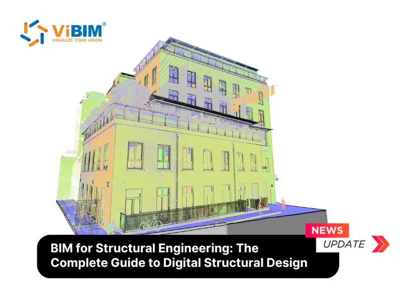
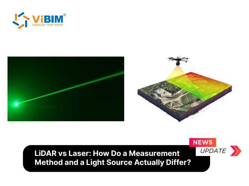
LiDAR (Light Detection and Ranging) is a remote sensing method that measures distance by firing laser pulses and timing their return. Laser (Light Amplification by Stimulated Emission of Radiation) is a device that generates a focused, coherent beam of light. LiDAR uses laser as its light source — but laser technology exists independently across hundreds of applications, from eye surgery to fiber optic communication.
This distinction matters. LiDAR is one specific application of laser technology, much like radar is one specific application of radio waves. Every LiDAR system contains a laser. Not every laser device is a LiDAR system. The two terms describe different levels of a technology stack — a light source versus a measurement method built around that source.
In the Architecture, Engineering, and Construction (AEC) industry, the confusion runs deeper. Professionals use ‘laser scanning’ and ‘LiDAR scanning’ to describe the same equipment — because most 3D terrestrial scanners operate on LiDAR principles. Both produce 3D laser scanning point cloud models, the coordinate datasets that form the foundation for Building Information Modeling (BIM). Understanding where laser ends and LiDAR begins helps AEC teams communicate clearly with scanning partners and modeling providers.
This article breaks down each technology on its own terms, maps the relationship between them, compares their applications, and shows how LiDAR fits into the Scan to BIM workflow.
What Is a Laser?
A laser is a device that produces a narrow, focused beam of light through a process called stimulated emission of radiation. The word “laser” stands for Light Amplification by Stimulated Emission of Radiation — a name that describes exactly how the device works. Unlike a lightbulb, which emits light in all directions across many wavelengths, a laser outputs a near single-wavelength (narrow-band) beam that stays tight over long distances.
Three properties separate laser light from ordinary light. Coherence means all photons travel in phase — their wave peaks align. This allows precise time-of-flight measurements, which is why LiDAR relies on laser rather than LED or incandescent sources. Monochromaticity means the beam contains a narrow band of wavelengths centered on a specific frequency — ranging from 905 nm (near-infrared) to 1550 nm (short-wave infrared) depending on the laser type. Collimation means the beam barely spreads over distance. A typical laser pointer maintains a 1mm (0.04 in) beam diameter across a room. Industrial and scientific lasers hold focus over kilometers.
How does a laser generate this light? The process starts with a gain medium — a material that amplifies photons. It can be a gas (CO₂ laser), a crystal (Nd:YAG solid-state laser), a semiconductor chip (laser diode), or a doped glass fiber (fiber laser). An external energy source “pumps” electrons in the gain medium to a higher energy state. When these electrons drop back down, they release photons. Two mirrors at each end of the gain medium bounce those photons back and forth, stimulating more emissions with each pass. One mirror is partially transparent, letting a portion of the amplified light escape as the laser beam.
Theodore Maiman built the first working laser in 1960 at Hughes Research Laboratories. Just one year later — 1961 — Hughes Aircraft developed the first LiDAR-like system for satellite tracking. The speed of that progression reveals something fundamental: laser was invented as a light source, and engineers immediately recognized its potential for distance measurement.
Laser types common across industries include gas lasers for metal cutting (CO₂ lasers cut steel up to 25mm / 1 in thick), solid-state lasers for precision welding, semiconductor laser diodes for barcode readers and optical disc drives, and fiber lasers for telecommunications and long-range LiDAR. The device you choose depends on the power, wavelength, and beam quality your application demands.
What Is LiDAR?
LiDAR is a remote sensing method that calculates distance by firing laser pulses at a surface and measuring how long the reflected light takes to return to a sensor. LiDAR stands for Light Detection and Ranging. It is a system, not a single device — combining a laser transmitter, a photodetector (receiver), a GPS unit, and an Inertial Measurement Unit (IMU) into one measurement platform.
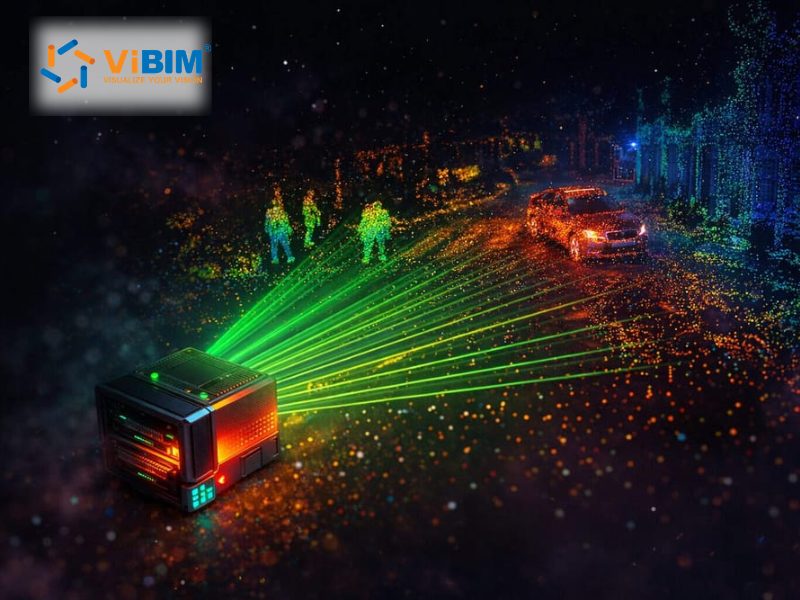
The core principle is time of flight. A laser fires a pulse. That pulse hits a surface — a wall, a tree, the ground — and bounces back. The sensor records the return time. Since light travels at 299,792,458 meters per second (186,282 miles per second), even nanosecond-scale timing differences translate into millimeter-level distance calculations. Repeat this millions of times per second across a rotating field of view, and the result is a point cloud — a dataset of millions of XYZ coordinates representing the scanned environment in three dimensions.
LiDAR systems use 3 main measurement principles. Time of Flight (ToF) fires discrete pulses and records return time. This is the most common method in terrestrial and aerial scanners. Phase-shift emits a continuous modulated beam and measures the phase difference between outgoing and returning light. It scans faster than ToF but over shorter ranges. FMCW (Frequency Modulated Continuous Wave) sweeps the laser frequency continuously, comparing outgoing and return signals to extract both distance and velocity. FMCW appears in autonomous vehicle sensors and industrial metrology systems.
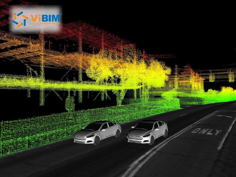
The output of any LiDAR system is point cloud data — 3D spatial information containing XYZ coordinates, intensity values (how strongly the surface reflected the pulse), and sometimes RGB color from an integrated camera. This data feeds directly into point cloud modeling software. In the AEC industry, point cloud files (E57, RCP/RCS, LAS/LAZ formats) are imported into Autodesk Recap and Revit for Scan to BIM conversion.
LiDAR has a specific origin story. Hughes Aircraft Company built the first system in 1961, initially called “Colidar” (coherent light detecting and ranging) — derived from “radar.” The public learned about LiDAR during the Apollo 15 mission in 1971, when astronauts used a laser altimeter to map the Moon’s surface. Since then, LiDAR has expanded from atmospheric research to surveying, autonomous driving, forestry, archaeology, and construction.
How Laser and LiDAR Relate: Device vs. Method
LiDAR uses laser as its light source, but laser does not depend on LiDAR. The relationship flows in one direction. Every LiDAR scanner contains a laser component. No laser device requires LiDAR to function. Understanding this hierarchy clears up the most common confusion between the two terms.
Think of it this way. Radar uses radio waves to detect objects and measure distance. But radio waves also carry music, television signals, and WiFi data. Radio is the foundational technology. Radar is one application. The same structure applies here. Laser is the foundational technology. LiDAR is one application that uses laser for distance measurement.
Another useful frame: every square is a rectangle, but not every rectangle is a square. Every LiDAR scanner is a laser device, but not every laser device is a LiDAR scanner. A barcode reader uses a laser. A laser printer uses a laser. A fiber optic cable transmits data using laser. None of these are LiDAR. Only systems that fire laser pulses and measure return time for distance calculation qualify as LiDAR.
Why does this confusion persist, especially in AEC? Because most 3D terrestrial scanners — the Leica RTC360, FARO Focus Premium, Trimble X7 — operate on LiDAR principles (time of flight or phase-shift). When a surveyor says “laser scanning a building,” they almost always mean using a LiDAR-based scanner. The terms overlap in daily practice even though they describe different things technically. “Laser scanning” is a broader category that includes LiDAR-based scanning, structured light scanning, and triangulation scanning. LiDAR is the specific distance measurement method inside most AEC scanners.
So when someone asks “is LiDAR a type of laser?” — the answer is no. LiDAR is a type of measurement system that uses a laser component. The laser generates light. The LiDAR system turns that light into distance data.
6 Key Differences Between Laser and LiDAR
Laser and LiDAR differ across 6 dimensions — nature, operating principle, output, components, application scope, and dependency relationship. Each difference reflects the gap between a foundational technology (laser) and a measurement system built on that technology (LiDAR).
Nature: Laser is a device — a physical instrument that generates coherent light. LiDAR is a method — a measurement approach that uses laser pulses to calculate distance. This is the most basic and most misunderstood distinction.
Operating principle: Laser works through stimulated emission: pumping energy into a gain medium causes electrons to release photons in phase, amplified between reflective surfaces. LiDAR works through time of flight: measuring the round-trip travel time of a laser pulse to determine how far away a surface sits. Laser creates the light. LiDAR interprets the reflection.
Output: Laser produces a beam of coherent, monochromatic light. LiDAR produces point cloud data — millions of 3D coordinate points (XYZ) with intensity and sometimes color values. One generates energy. The other generates spatial information.
Components: A laser requires 3 elements: a gain medium, an energy pump, and an optical resonator (mirrors). A LiDAR system requires 4+ elements: a laser transmitter, a photodetector, GPS, IMU, and processing electronics. LiDAR includes a laser. A laser does not include LiDAR.
Application scope: Laser spans medicine (LASIK eye surgery, tissue ablation), manufacturing (cutting up to 25mm / 1 in steel, welding, engraving), telecommunications (fiber optic data at terabit speeds), consumer electronics (Blu-Ray players, barcode scanners, laser printers), defense (rangefinders, target designation), and scientific research (spectroscopy, fusion experiments). LiDAR focuses on spatial measurement — topographic mapping, autonomous vehicle navigation, construction surveying, forestry monitoring, archaeological discovery, and atmospheric science.
Dependency: LiDAR always requires laser technology. Laser never requires LiDAR. This one-directional dependency defines their hierarchy.
The table below summarizes these differences side by side.
| Criteria | Laser | LiDAR |
| Full name | Light Amplification by Stimulated Emission of Radiation | Light Detection and Ranging |
| Nature | Device (light source) | Method / System (measurement platform) |
| Principle | Stimulated emission → coherent light | Time of flight / phase-shift → distance data |
| Output | Coherent light beam | Point cloud data (XYZ + intensity) |
| Core components | Gain medium, pump, resonator | Laser + photodetector + GPS + IMU |
| Key industries | Medicine, manufacturing, telecom, defense, consumer electronics | Surveying, autonomous vehicles, AEC, forestry, archaeology |
| Dependency | Independent technology | Depends on laser as light source |
| Year introduced | 1960 (Theodore Maiman) | 1961 (Hughes Aircraft — “Colidar”) |
The classification logic is straightforward: laser is the foundational technology layer, LiDAR is the application layer. They sit at different levels of the same technology stack. Confusing them is like confusing electricity with a computer — one powers the other, but they serve different functions.
Applications of Laser and LiDAR Across Industries
Laser serves hundreds of applications across medicine, manufacturing, telecommunications, and consumer products. LiDAR focuses specifically on 3D distance measurement — with major use in surveying, autonomous vehicles, and the AEC industry. The scope difference reflects their nature: a foundational technology versus a purpose-built system.
Laser applications span nearly every industry. In medicine, CO₂ and excimer lasers perform LASIK eye correction, and surgical lasers cut tissue with sub-millimeter precision. Manufacturing uses high-power lasers to cut, weld, drill, and engrave metals, plastics, and composites — CO₂ lasers slice through 25mm (1 in) steel plates. Telecommunications depends on semiconductor lasers to transmit data through fiber optic cables at speeds exceeding 100 terabits per second across ocean floors. Consumer products contain lasers in Blu-Ray/DVD players, barcode scanners, laser printers, and laser pointers. Defense and research use laser rangefinders, laser-guided munitions, and laser spectroscopy for atmospheric analysis.
LiDAR applications center on spatial measurement and 3D mapping. The United States Geological Survey (USGS) uses airborne LiDAR to build the 3D Elevation Program (3DEP) — a high-resolution terrain model covering the entire country. Autonomous vehicle companies equip self-driving cars with LiDAR sensors that detect obstacles, pedestrians, and lane markings at distances up to 200 meters (656 ft) in real time. Forestry agencies measure canopy heights, assess deforestation rates, and model fire risk using airborne LiDAR that penetrates tree cover to map the ground surface beneath. Archaeologists discovered an entire hidden Maya city in Guatemala using LiDAR that peered through dense jungle canopy — structures invisible from the ground became clear from point cloud data.
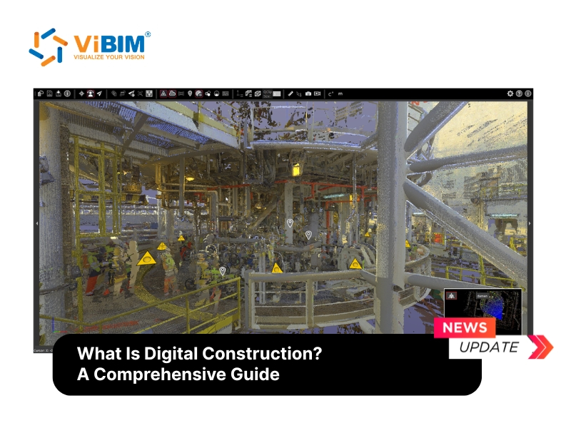
In the AEC industry, LiDAR drives 6 primary workflows: as-built documentation (capturing existing building conditions), renovation and retrofit planning, construction progress monitoring, heritage preservation (recording historic structures at millimeter-level detail), topographic surveying before construction, and facility management (maintaining accurate digital records of completed buildings).
What connects all LiDAR applications is the same output: point cloud data. A set of XYZ coordinates, captured by laser pulses, processed into 3D spatial models. Whether the scanner sits on a tripod, a drone, or the roof of a self-driving car, the measurement method remains the same — fire laser, time the return, calculate distance.
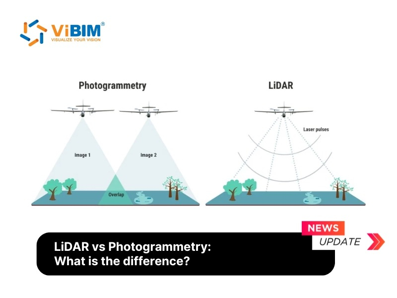
Some projects combine LiDAR with camera-based capture — see LiDAR vs photogrammetry for a side-by-side comparison.
LiDAR in AEC: From Laser Pulses to Point Cloud to BIM Model
In the AEC industry, LiDAR scanners fire laser pulses to capture existing building conditions as point cloud data — which then feeds into the Scan to BIM process, converting raw 3D coordinates into accurate Building Information Models in Revit.
The workflow follows 5 stages. First, a LiDAR scanner captures the physical environment. For building interiors and exteriors, teams typically use terrestrial scanners for 3D laser Scan to BIM – models like the Leica RTC360 or FARO Focus Premium lead the market. For large-area coverage at speed, mobile scanners like the Leica BLK2GO or NavVis VLX — fast but noisier. For site topography, roof inspection, or bridge surveys, drone-mounted LiDAR (DJI Zenmuse L2, RIEGL VQ-1560 II-S) covers square kilometers at typically on the order of 5-15cm vertical accuracy.
Second, the raw scan data goes through registration — aligning multiple scan positions into a single coordinate system. Third, processing removes noise, outliers, and unwanted data. Fourth, the cleaned point cloud file (typically E57, RCP/RCS, or LAS format) is imported into Autodesk Recap and then into Revit. Fifth, BIM modelers trace over the point cloud to create accurate 3D representations of walls, floors, ceilings, structural elements, and MEP (Mechanical, Electrical, Plumbing) systems — a process covered under architectural Scan to BIM services for building envelope and interior elements.
The quality of the laser source directly affects the point cloud, which in turn affects the BIM model. Dense, low-noise point clouds from terrestrial LiDAR (TLS) support detailed modeling at LOD 300-400 — geometry accurate to within 1-2mm of physical reality. Point clouds from mobile LiDAR carry more noise and lower density, limiting practical modeling to LOD 200-300 and increasing cleanup time by roughly 20%.
FAQs
Is LiDAR a Laser?
No. LiDAR uses a laser but is not itself a laser. LiDAR is a measurement method. Laser is a light-emitting device. The relationship mirrors radar and radio — radar uses radio waves for detection, but radar is not a radio. In AEC contexts, the terms blur because most 3D terrestrial scanners operate on LiDAR time-of-flight principles, making “laser scanning” and “LiDAR scanning” functionally interchangeable for building surveys.
What Type of Laser Does LiDAR Use?
LiDAR systems commonly use 2 laser types — semiconductor laser diodes at 905nm and fiber lasers at 1550nm. The 905nm wavelength pairs with affordable silicon photodiodes and dominates terrestrial scanning and robotics applications. The 1550nm wavelength is safer for human eyes at higher power levels, penetrates dust and haze better, and reaches longer distances — but requires more expensive InGaAs detectors. Most AEC terrestrial scanners, including the Leica RTC360 and FARO Focus series, use Class 1 eye-safe laser sources that allow unrestricted use in occupied buildings.
Why Do People Use “Laser Scanning” and “LiDAR” Interchangeably?
Because in surveying and AEC, most 3D laser scanners operate on LiDAR principles — time of flight or phase-shift distance measurement. When a surveyor says “laser scanning a building,” they mean a LiDAR-based terrestrial scanner. The terms overlap in practice, even though “laser scanning” is technically broader. It includes structured light scanning and triangulation methods that do not use LiDAR’s time-of-flight approach. In a BIM context, when a project brief says “provide laser scan data,” it means point cloud data captured by a LiDAR scanner.
ViBIM delivers point cloud modeling services from scan data. As a dedicated Revit BIM modeling services provider, the team uses Revit as its primary authoring tool within the Autodesk platform. The team supports building surveyors, existing and as-built documentation, and design and engineering projects across architectural, structural, MEP, and topographic disciplines. Contact ViBIM to discuss your project requirements and receive a complimentary quote.
Vietnam BIM Consultancy and Technology Application Company Limited (ViBIM)
- Address: 10th floor, CIT Building, No 6, Alley 15, Duy Tan street, Cau Giay ward, Hanoi, Vietnam
- Phone: +84 944 798 298
- Email: info@vibim.com.vn