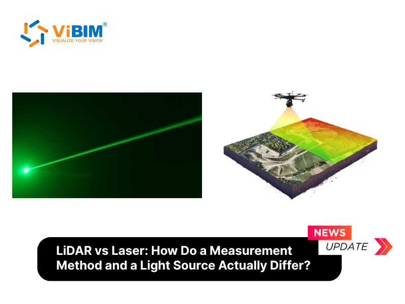
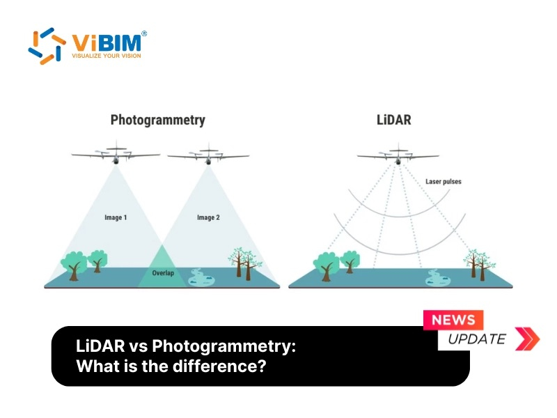
The main difference between LiDAR and photogrammetry is how they capture 3D spatial data: LiDAR measures distances directly with laser pulses, while photogrammetry calculates geometry from overlapping photographs. Both techniques create visual representations of structures and terrain, but their mechanisms, accuracy levels, and optimal use cases differ significantly.
LiDAR uses laser light to measure distances with high accuracy, generating dense point clouds that describe the shape and size of physical objects. Photogrammetry relies on overlapping photographs taken from multiple angles, and software calculates 3D coordinates by comparing points across the images. LiDAR is an active sensing method that emits laser pulses, while photogrammetry is a passive imaging method that depends on reflected light.
Each technology has advantages and limitations that make them suitable for different project needs. This LiDAR vs Photogrammetry comparison explains how each technology works, compares their differences across accuracy, cost, and environmental performance, and provides decision criteria for surveying, mapping, and Scan to BIM projects.
What is LiDAR?
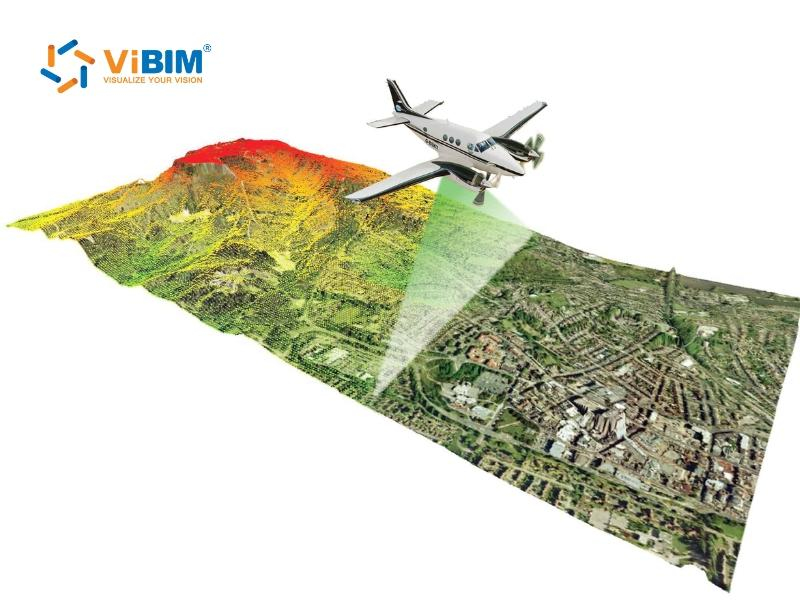
LiDAR uses laser light to measure distances and create highly accurate 3D representations of physical environments. The sensor emits rapid pulses of light, and the time it takes for each pulse to bounce back determines the distance to surrounding objects. This data forms a detailed point cloud model that captures the shape and elevation of surfaces. LiDAR technology supports applications in mapping, surveying, autonomous vehicles, and infrastructure modeling.
What is photogrammetry?
Photogrammetry collects 3D information by processing overlapping photographs taken from different viewpoints. Specialized software detects matching points in the images and calculates their positions in three-dimensional space. This method generates realistic 3D models, textured maps, and topographic data. Fields such as architecture, engineering, visual effects, and space research widely apply photogrammetry to accurately document and analyze objects or terrain.
What is the difference between LiDAR and photogrammetry?
LiDAR measures geometry directly with lasers; photogrammetry derives geometry visually from images. LiDAR emits laser pulses that bounce off surfaces and return to the sensor—measuring direct distances to create 3D point clouds. Photogrammetry captures overlapping photographs from multiple angles, then uses triangulation algorithms to calculate depth and reconstruct 3D geometry.
Both technologies produce point clouds and 3D models. However, LiDAR excels at geometric precision and works in any lighting condition. Photogrammetry excels at visual realism and costs less to deploy. The choice depends on project requirements: accuracy tolerance, site conditions, budget, and deliverable type.
For a deeper understanding of these output formats, you can compare a point cloud model vs mesh model.
The table below compares LiDAR and photogrammetry across ten criteria that influence technology selection for surveying, mapping, and Scan to BIM projects:
| Criteria | LiDAR | Photogrammetry |
| Data Collection Method | Active sensing: emits laser pulses at 100,000–2,000,000 pulses/second | Passive sensing: captures overlapping photographs (70–90% overlap required) |
| Output Data | 3D point clouds (XYZ coordinates + intensity values) | 2D images processed into 3D (XYZ coordinates + RGB color) |
| Capture Speed | Fast: indoor scans complete in 2–5 minutes per station | Slower: requires hundreds of overlapping images across the site |
| Processing Time | Varies by project size; typically faster registration than photogrammetry for complex structures | Hours to days depending on image count and model complexity |
| Accuracy | Terrestrial: ±1–5mm (0.04–0.2 in); Aerial/UAV: ±3–10cm (1.2–4 in) depending on altitude & sensor | Horizontal: ±3–8cm (1.2–3.1 in); Vertical: ±8–15cm (3–6 in) with GCPs |
| Vegetation Performance | Laser pulses penetrate canopy gaps to capture ground beneath foliage | Captures only visible surfaces; dense vegetation blocks ground data |
| Lighting Requirement | Works day or night; unaffected by shadows or glare | Requires consistent daylight; shadows and glare reduce model quality |
| Visual Detail | High geometric precision; limited color unless RGB camera integrated | Photorealistic output with true-color textures from source photographs |
| Equipment Cost | Terrestrial scanners: $20,000–$100,000 (e.g., Leica BLK360: ~$19,000; Leica RTC360: ~$80,000) | Survey drone + camera: $1,000–$8,000 (e.g., DJI Mavic 3 Enterprise: ~$5,000) |
| Best Applications | Forestry, topography, as-built documentation, Scan to BIM | Architecture visualization, media production, design rendering |
Each criterion above affects data quality, project timeline, and cost. The following sections explain these differences in detail:
Data capture method
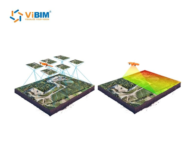
LiDAR emits laser pulses and measures return time to calculate distances directly; photogrammetry captures overlapping photographs and uses triangulation to compute 3D positions. These fundamentally different mechanisms affect data quality, capture speed, and project suitability.
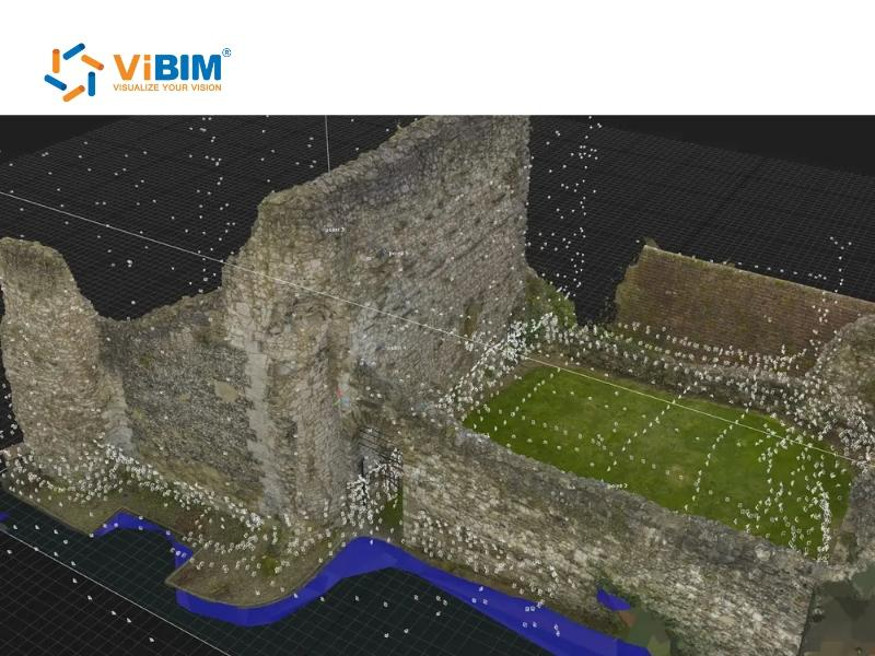
LiDAR actively emits laser pulses—modern terrestrial scanners like the Leica RTC360 fire up to 2 million pulses per second. Each pulse bounces off a surface and returns to the sensor. The scanner measures return time at nanosecond precision, then calculates exact distances. This process generates a dense lidar point cloud 3D model containing millions of XYZ coordinates.
Photogrammetry works passively. A camera or drone captures hundreds of overlapping photographs from different positions and angles. Photogrammetry software like Agisoft Metashape or Pix4D analyzes these images, detects matching feature points across overlapping frames, and calculates 3D positions through triangulation. For accurate reconstruction, images require 70–80% forward overlap and 60–70% side overlap. Each surface point must appear in at least three to four photographs.
Accuracy and precision
LiDAR achieves higher geometric accuracy than photogrammetry under most conditions. Terrestrial LiDAR scanners deliver ±1–5mm (0.04–0.2 in) accuracy. The Leica RTC360 achieves 1.9mm accuracy at 10 meters (33 ft) and 2.9mm at 20 meters (66 ft). In practical applications, these figures represent the reliable precision attainable under optimal scanning conditions and rigorous workflow controls. Aerial LiDAR systems achieve ±5–10cm (2–4 in) vertical accuracy on non-vegetated terrain, meeting ASPRS Accuracy Class II standards.
Photogrammetry accuracy depends on multiple variables: image quality, overlap percentage, ground control point placement, lighting conditions, and surface texture. Under optimal conditions with proper ground control, UAV photogrammetry achieves horizontal accuracy of ±3–8cm (1.2–3.1 in). Vertical accuracy varies more—typically ±8–15cm (3–6 in)—because depth calculation relies on triangulation rather than direct measurement.
LiDAR is less dependent on texture but is still affected by highly reflective, transparent, or absorptive materials. Surfaces such as glass, water, and polished metal can result in lost returns or noisy data, while black light-absorbing surfaces may reduce effective range. Photogrammetry struggles with uniform surfaces like snow, water, sand, and polished concrete where the software cannot detect distinct feature points. For projects demanding sub-centimeter dimensional precision—such as industrial facility documentation or heritage preservation—utilizing 3D laser scanning point cloud models delivers more reliable results.
Vegetation and terrain performance
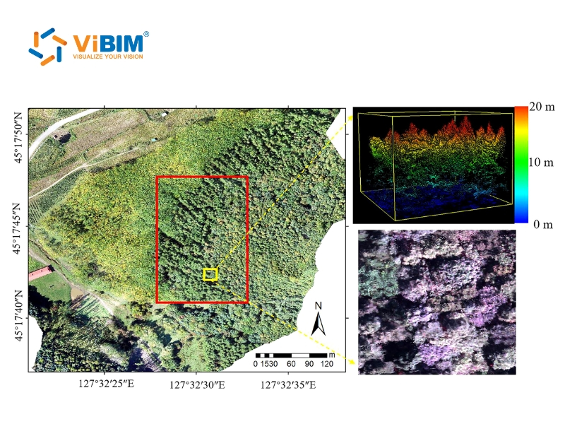
LiDAR penetrates vegetation canopy to capture ground-level data. Laser pulses travel through gaps in foliage, reflect off the forest floor, and return to the sensor. Modern LiDAR systems process multiple returns per pulse—up to five echoes—allowing simultaneous mapping of canopy layers and ground surface. This capability makes LiDAR essential for forestry inventory, Topography Scan to BIM Services, and flood modeling in vegetated areas.
Photogrammetry captures only what the camera sees. Dense vegetation, tree canopy, and obstructed areas produce incomplete ground models. The camera cannot photograph surfaces hidden beneath leaves or behind obstacles. In forested terrain, photogrammetry generates digital surface models (showing treetop elevation) but cannot produce accurate digital terrain models (showing ground elevation).
When the project requires ground-level accuracy beneath vegetation, LiDAR has a clear advantage. When the project involves open terrain with varied textures—construction sites, agricultural fields, urban areas—photogrammetry performs well.
Environmental and lighting conditions
LiDAR geometry capture operates independently of ambient light. The laser emitter generates its own illumination, so LiDAR scanners work equally well at noon, midnight, or in overcast conditions. Data quality is unaffected by ambient lighting conditions (shadows, darkness), though highly reflective or wet surfaces may still require special handling. This independence makes LiDAR ideal for indoor scanning, underground utilities, tunnels, and projects requiring night operations.
Photogrammetry depends on consistent, even lighting. The camera needs adequate ambient light to capture sharp, well-exposed images. Harsh shadows create contrast problems. Glare from reflective surfaces—glass, polished metal, wet pavement—causes data gaps. Low-light conditions produce noisy images that degrade model quality. Optimal photogrammetry conditions include overcast skies or midday sun with minimal shadows.
For indoor environments, photogrammetry requires supplemental lighting or flash. LiDAR requires no lighting modification. In challenging environments—low light, high contrast, reflective surfaces—LiDAR produces more consistent results.
Visual detail and realism
Photogrammetry produces visually superior output. Because photogrammetry reconstructs models from actual photographs, the output includes true-color RGB textures captured directly from the source images. The resulting 3D models appear photorealistic—ideal for architecture visualization, virtual tours, media production, and design presentations.
LiDAR output focuses on geometry. Point clouds contain XYZ coordinates and intensity values (measuring surface reflectivity) but lack inherent color information. Some LiDAR systems integrate RGB cameras to colorize point clouds, but the visual quality does not match photogrammetry. LiDAR models excel at dimensional accuracy; photogrammetry models excel at visual realism.
During the Architectural point cloud to BIM process, this distinction matters. LiDAR provides the geometric foundation—accurate measurements for walls, floors, ceilings, columns, and MEP systems. Photogrammetry provides visual context—textures, colors, and surface details that help modelers identify materials, finishes, and asset conditions.
Cost, equipment, and efficiency
LiDAR requires specialized hardware with significant upfront investment. Entry-level terrestrial scanners like the Leica BLK360 cost approximately $19,000. Professional-grade systems like the Leica RTC360 exceed $80,000. In the past three years, mobile mapping systems such as the NavVis VLX and Leica BLK2GO have gained significant popularity, offering rapid capture solutions for large-scale facilities. High-end Drone-mounted LiDAR systems can cost $150,000+, while modern entry-level professional systems start around $30,000–$50,000. Annual software licensing adds $3,000–$15,000.
Photogrammetry equipment costs less. A survey-capable drone like the DJI Mavic 3 Enterprise costs $5,000–$8,000. Entry-level mapping drones start under $1,000. Many professionals already own suitable cameras. Photogrammetry software ranges from free open-source options to professional packages at $2,000–$8,000 annually.
However, cost comparisons must include time efficiency. For complex indoor facilities, LiDAR captures data faster—a 50,000 square foot (4,600 m²) facility requires 4–6 hours to scan with LiDAR versus 8–10 hours with photogrammetry. LiDAR processing is generally faster and requires less manual cleanup than photogrammetry for complex structures. For time-critical projects or complex sites, LiDAR’s speed may offset its higher equipment cost.
For budget-conscious projects with flexible timelines, photogrammetry offers lower barriers to entry. However, when factoring in the total 3D point cloud to BIM service price, LiDAR delivers better cost efficiency per deliverable for large-scale projects requiring rapid turnaround.
Ease of use and learning curve
LiDAR is easier to deploy consistently; photogrammetry demands deeper technical expertise but rewards skilled operators with richer visual output. Modern LiDAR platforms feature automated workflows that simplify operation—scanners like the Leica RTC360 and FARO Focus Premium include one-touch scanning, automatic registration, and field verification apps. Operators can capture accurate data with minimal training—basic proficiency develops within days. The learning curve centers on understanding scan coverage, target placement, and point cloud processing software.
Photogrammetry requires understanding camera settings (aperture, shutter speed, ISO), flight planning (altitude, speed, overlap ratios), and ground control point surveying. Post-processing requires experience with photogrammetry software, quality control procedures, and troubleshooting reconstruction failures. Most users achieve basic proficiency within weeks, but mastering photogrammetry for survey-grade results takes months of practice.
These seven comparison factors—data capture method, accuracy, vegetation handling, lighting requirements, visual quality, cost, and ease of use—determine which technology fits your project. The following section provides decision thresholds and industry-specific recommendations to guide your technology selection.
When to use LiDAR vs photogrammetry
Choose LiDAR when your project demands sub-centimeter accuracy, operates in vegetated or low-light environments, or requires fast data capture. Choose photogrammetry when visual realism matters most, budget is limited, or the site offers clear terrain with consistent lighting. The decision depends on five factors: accuracy tolerance, site conditions, equipment budget, project timeline, and deliverable requirements.
The table below provides specific thresholds for each decision factor:
| Decision Factor | Choose LiDAR | Choose Photogrammetry |
| Accuracy Tolerance | ±1–5mm (0.04–0.2 in) required | ±3–10cm (1.2–4 in) acceptable |
| Vegetation Cover | >30% canopy or dense foliage | <30% canopy, cleared terrain |
| Lighting Conditions | Indoor, nighttime, tunnels, variable light | Consistent daylight, overcast preferred |
| Equipment Budget | >$20,000 available for hardware | <$10,000 total equipment cost |
| Project Timeline | Deliverables needed within 24–48 hours | 3–7 days processing time acceptable |
| Site Complexity | Multi-level structures, MEP systems, confined spaces | Open areas, facades, landscapes |
| Deliverable Type | Geometry-focused: BIM models, CAD drawings | Visual-focused: renders, orthophotos, textured models |
These thresholds reflect typical project scenarios. It is important to note that Photogrammetry point clouds typically require 30–50% more cleanup time due to noise, holes, and lower geometric consistency.
In practice, clients often use photogrammetry for tasks like roof scanning to reduce equipment costs. However, this approach frequently results in a significant increase in modeling effort (and time) because the point cloud quality is inferior compared to LiDAR, requiring modelers to interpret vague geometries or fill in data gaps manually. Some projects benefit from combining both technologies—LiDAR for geometric accuracy and photogrammetry for visual documentation.
Accuracy-driven technology selection
Project accuracy requirements determine technology choice more than any other factor. Scan to BIM projects for renovation, retrofit, and facility management typically require ±3–5mm (0.12–0.2 in) dimensional accuracy to ensure MEP coordination and clash detection. At this tolerance, terrestrial LiDAR delivers reliable results. Photogrammetry cannot consistently achieve sub-centimeter accuracy.
For projects where ±5–10cm (2–4 in) accuracy meets requirements—site documentation, progress monitoring, volumetric calculations—photogrammetry offers a cost-effective alternative. When specifications require ASPRS Accuracy Class I or II standards, LiDAR provides greater margin for compliance.
Site condition assessment
Site characteristics often eliminate one technology option before budget or timeline factors enter the decision.
- Vegetation and obstructions: Sites with >30% canopy cover, dense undergrowth, or seasonal foliage require LiDAR to generate accurate digital terrain models. Forestry surveys, floodplain mapping, and utility corridor assessments in vegetated areas default to LiDAR.
- Lighting environment: Indoor surveys without supplemental lighting, nighttime operations, and sites with extreme shadows or glare favor LiDAR. Photogrammetry requires consistent, even lighting—ideally overcast daylight or controlled artificial illumination.
- Surface characteristics: Sites dominated by reflective, transparent, or monochromatic surfaces—glass facades, polished concrete, fresh snow, calm water—require LiDAR or supplemental targets. Photogrammetry software cannot detect feature points on homogeneous surfaces.
Deliverable requirements by industry
Different industries prioritize different deliverable characteristics. The table below matches industry applications with recommended technology:
| Industry | Primary Deliverable | Recommended Technology | Rationale |
| AEC / Scan to BIM | Revit models at LOD 200–400 | LiDAR | ±3–5mm accuracy for MEP coordination |
| Facility Management | As-built floor plans, asset inventory | LiDAR | Dimensional accuracy for space planning |
| Historic Preservation | HABS/HAER documentation | LiDAR + Photogrammetry | Geometry + visual record for archives |
| Construction Monitoring | Progress documentation | Both viable | LiDAR for accuracy; photogrammetry for visual |
| Real Estate / Marketing | Virtual tours, 3D visualizations | Photogrammetry | Photorealistic textures for visual appeal |
| Mining / Earthworks | Stockpile volumes, cut/fill analysis | Both viable | Photogrammetry for open pits; LiDAR for precision |
| Forestry | Terrain models, biomass estimation | LiDAR | Canopy penetration essential |
| Utilities / Infrastructure | Corridor mapping, clearance analysis | LiDAR | Vegetation removal, precise measurements |
Hybrid workflows: combining LiDAR and photogrammetry
Many projects achieve optimal results by deploying both technologies. LiDAR establishes geometric accuracy; photogrammetry adds visual context. This hybrid approach works well for:
- Heritage documentation: LiDAR captures precise geometry of historic structures—moldings, ornamental details, structural elements. Photogrammetry records surface textures, paint colors, material conditions, and weathering patterns. Combined deliverables satisfy both dimensional and archival requirements.
- Large facility surveys: Interior spaces scanned with terrestrial LiDAR achieve ±3mm accuracy for BIM modeling. Exterior facades and site context captured with drone photogrammetry add visual documentation at lower cost than aerial LiDAR. The datasets merge in processing software.
- Construction verification: LiDAR scans verify dimensional compliance against design models. Photogrammetry documents visual progress for stakeholder communication. Both datasets timestamp construction phases for dispute resolution and record-keeping.
Sensors like the DJI Zenmuse L2 capture LiDAR and photogrammetry data simultaneously, enabling colorized point clouds from a single flight. This convergence simplifies hybrid workflows for aerial applications.
LiDAR vs photogrammetry for Scan to BIM projects
LiDAR produces more reliable Scan to BIM deliverables than photogrammetry. Professional Scan to BIM services convert point cloud data into intelligent BIM models—a process requiring ±3–5mm (0.12–0.2 in) dimensional accuracy to create coordination-ready Revit models. Terrestrial LiDAR achieves this tolerance consistently. Photogrammetry achieves it only under optimal conditions and struggles with interior environments where most Scan to BIM projects focus.
Interior documentation demands LiDAR. MEP systems, structural elements, and architectural details require sub-centimeter precision for clash detection and construction coordination. Complex indoor environments challenge photogrammetry: variable lighting affects exposure consistency, reflective surfaces (glass partitions, polished floors, stainless steel equipment) create data voids, and occluded areas behind columns or ductwork produce incomplete coverage. LiDAR’s active sensing overcomes these limitations—the laser measures distances regardless of ambient light or surface texture.
Exterior context benefits from photogrammetry. Building facades, surrounding terrain, and site context captured with drone photogrammetry supplement interior LiDAR data cost-effectively. Aerial photogrammetry achieves ±5–10cm (2–4 in) accuracy—sufficient for site plans, massing models, and design visualization. This hybrid approach delivers comprehensive documentation: LiDAR precision for interior BIM modeling, photogrammetry visuals for stakeholder communication.
The table below matches LOD specifications with recommended capture technology:
| LOD Level | Accuracy Tolerance | Recommended Technology | Typical Applications |
| LOD 100–200 | ±25–100mm (1–4 in) | Photogrammetry acceptable | Conceptual design, space planning |
| LOD 300 | ±10–15mm (0.4–0.6 in) | LiDAR required | Design development, coordination |
| LOD 350–400 | ±3–10mm (0.12–0.4 in) | Terrestrial LiDAR required | Construction documents, MEP coordination |
| LOD 500 | As-built verified | Terrestrial LiDAR + field validation | Facility management, asset tracking |
For projects requiring LOD 300 or higher—MEP coordination, clash detection, renovation planning—LiDAR provides the geometric accuracy that BIM modelers need. Our project experience confirms this: photogrammetry-sourced models typically require significantly more cleanup time to achieve equivalent dimensional reliability.
As a leading Revit BIM modeling service provider, ViBIM processes both LiDAR point clouds and photogrammetric data to create comprehensive Revit models at LOD 100–500. Our team evaluates each project’s accuracy requirements, site conditions, and deliverable specifications to recommend the appropriate capture technology. Whether your data comes from terrestrial scanners, mobile mapping systems, or UAV platforms, ViBIM transforms raw point clouds into coordinated BIM deliverables with 99% on-time delivery and 30% faster turnaround than industry average.
Ready to convert your scan data into BIM models? Contact our team to discuss your project requirements—we respond within 24 hours with assessment and pricing.